One of the most charming places we've ever stayed was at Lillikoi B&B in Derry, Northern Ireland. We were so glad we had chosen to stay there for two nights as William and Eileen made us feel totally welcome in their charming home. We were especially fortunate being the only guests both nights. It was immediately evident Eileen's passion was their delightful flower and vegetable garden.


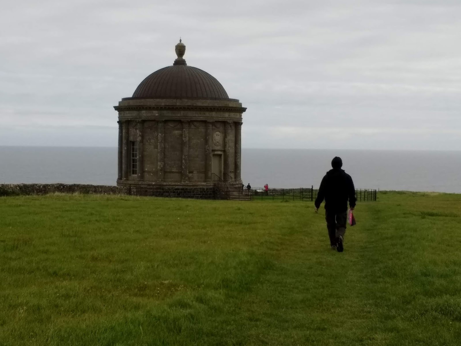
Downhill Demesne offered the stunning landscape of an 18th century mansion, now in ruins, that had belonged to the eccentric Earl Bishop, and the magnificent Mussenden Temple. One of the most colorful characters of the 18th century, Bishop chose this dramatic headland to build his grand country house. He filled it with treasures from all over Europe and spent a fortune landscaping the grounds.

The Bishops' large household as well as his busy entertainment schedule made big demands on the Walled Garden. It had to provide all the fruit, vegetables and herbs for the kitchen. Guests were treated to some of the more exotic varieties such as peaches, grapes and cucumbers, all grown in the greenhouse. It also provided flowers for the house in winter. An ice house was added in 1786. The garden consisted of stone-walled rectangular areas on a south-facing slope. That was subsequently disused and grass was placed over the garden.


Keeping doves in the dovecote was common practice on estates as the birds had many uses. The down and feathers were used to fill feathers and the dung was not only a highly rated fertilizer, it was also used in the tanning industry and in the manufacture of gunpowder. However, it was for their flesh and eggs, particularly in winter when meat was scarce, that doves were particularly valued. The dovecote was built in 1786 and accommodated 100 pairs of birds. Like many of the the Bishops' buildings, it was circular with a domed roof. The basement contained the ice house where meat, game, fish and poultry were used.


After seeing the dovecote, we traipsed across the field to Mussenden Temple that we had just seen from Downhill Beach.


The temple or library was named in honor of his cousin, Mrs. Frideswide Mussenden whose beauty Bishop greatly admired. The walls were once covered with bookcases. A fire was kept constantly burning in the basement and an enclosed flue meant that even in the very exposed location, the books never got damp.


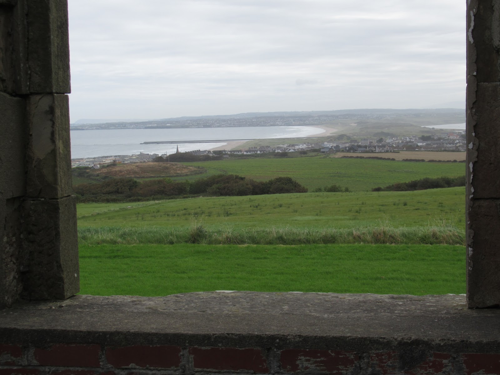
If it had been clearer, we would have had marvelous panoramic views to the west, to the beautiful beaches at the mouth of Lough Foyle and the County Donegal coast, to the north and the Scottish coast, and to the east to the Causeway coast. We'd hoped to see a pod of whales or porpoises in the waves below. Even if we didn't see any seabirds, we did hear some nesting on the ledges below.


Another of Bishop's consuming interests was architecture. This vast mansion, begun in 1775, was the first of his buildings in Ireland. The house was lived in by the Bruce family until 1922. During WW II, it was used as billets for Royal Air Force men and women. After it was sold in 1944, it sadly fell into disrepair.

I loved reading that Bishop had a great sense of humor, sprinkling the corridors of the guest wing with flour last thing at night to see, come morning, who had been visiting whom in the wee hours!


We stopped next for a while in the town of Portstewart to look at Portstewart Strand or beach. If we'd had more time, we would have headed for Barmouth, a nearby nature and wildlife reserve for migrant waterfowl, waders and nesting birds. The schoolkids looked like they were having a blast clambering over the cliffs!


A few miles up the road was Whiterocks Coastal Park. The sandy beach was backed by dunes and white limestone cliffs which were rich in biodiversity. The beach was a popular place for water sports but people had to be careful because of rip tides. A clifftop path headed east towards Dunluce Castle but we drove later toward the castle. Whiterocks took its name from the short stretch of chalk cliffs which made up part of the Cretaceous Ulster white limestone formation. The cliffs with their many arches, caves, stacks and plant communities were protected as an Area of Special Scientific Interest.

A Blue Flag Award Winning Beach was an environmental award given to beach operators that made a special effort to manage their coastal water environment and beaches. To attain the Blue Flag, beach operators had to fulfill a number of criteria covering water and coastal quality, environmental information and education, safety, and facilities. The beautiful beach at Whiterocks had earned Blue Flag status.


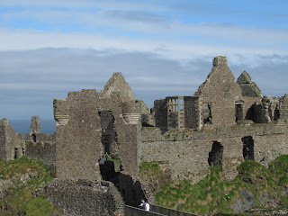
A few miles further on was Dunluce Castle, dramatically positioned on this sheer headland. It was built between the 15th and 17th centuries and, at that time, would have been one of the finest castles in the region and served to control the land and sea routes of North Ulster. Dunluce Castle ruins occupied what had been a site of human settlement from at least the Iron Age. Standing 100 feet above the sea, Dunluce meant 'strong fort.'


The town at Dunluce was destroyed during the 1641 rebellion. An annual fair was held among the ruins into the 18th century. The faint earthworks in the field were a small reminder of the town. The Earls of Antrim, owners of this land for centuries, have protected these remains by allowing the fields to lie fallow.

This stable housed the lord's horses and those of his visitors. The steps beside the entrance represented a mounting platform to help riders mount their horses. Wooden platforms would have separated the individual horse stalls. Excavations in this building produced evidence of butchered horse bone, showing that horse meat was part of the 17th century diet.


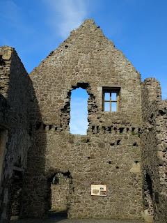
Each of the rooms had a fireplace and window. The inner wall had collapsed and was lying on the ground in front of where it would have once stood.


A row of columns was originally part of a loggia or a covered walkway which looked out over a garden that once occupied the site where the manor house stood. The loggia was installed by the MacDonnells as a fashionable architectural feature adopted from southern Europe.


Opposite the front of the Manor House was a large hole at the cliff edge, now covered with bars, because of cliff erosion and collapse in the 18th century.


That's Steven poking his head out of the Northwest Tower!


The Manor House was the remains of a Jacobean mansion built by Randal MacDonnell in 1620. A staircase would have led to the first floor where the main hall and family quarters were located.
The scorched stones of the fireplace and domed ovens in the wall were all that remained of a kitchen - once a smoky, bustling hub of activity. Can you imagine the staff struggling to keep the dishes warm from here to the Manor House on a stormy night!


The inner walled enclosure known as the Inner Ward was probably created by the MacDonnells in the 1550s.


The next point of interest was the striking Aird Snout. The rocks, photographed with a telephoto lens, looked like mini skyscrapers, I thought!


This was the windiest part of the trail so we needed to be extra careful.


Giant's Chair once had a different shape before the force of the waves and erosion changed it over time. Winds, seas, frost and rain constantly change the views.


We were treated like royalty dining on a full Irish breakfast each morning that consisted of eggs, no-fat bacon, sausages, toast and black and white pudding which was like a like a type of sausage. No wonder, doctors call those breakfasts 'heart attack specials'!


There was even marvelous view of Lough Foyle and the Inishowen Peninsula that we'd toured the previous day from their front yard!


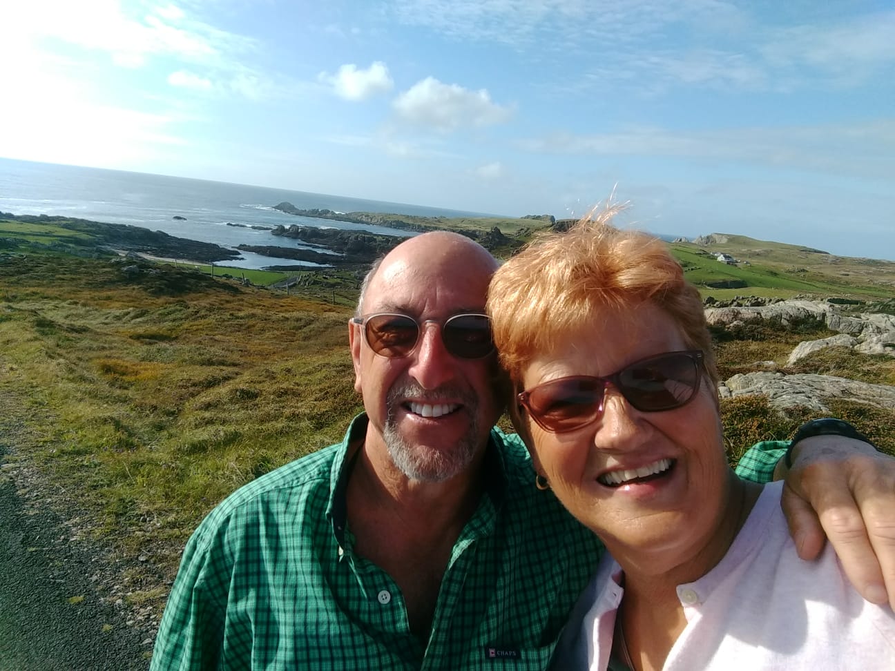
Leaving their gorgeous home across from Derry, we headed up the Antrim Coast toward Giant's Causeway. Seeing a sign for Downhill Beach piqued our interest as we were in no rush. How beautiful this sandy beach would have been in the height of the summer when it was a few degrees warmer.


Perched on a cliff in the distance was Mussenden Temple, our next stop.


This was the first and only train we saw the entire month in Ireland.


After seeing the dovecote, we traipsed across the field to Mussenden Temple that we had just seen from Downhill Beach.


In another direction was Downhill Estate which we would see shortly.

The vibrant green of the grass that I had come to associate with Ireland caught my attention here.


The inscription around the dome was by Lucretius: "Tis pleasant, safely to behold from shore, the rolling ships and hear the tempest roar."


Perched on the cliffs overlooking Downhill Strand or beach, it was once possible to drive a horse and carriage around the temple. However, the forces of nature over the years had brought it closer and closer to the edge.


I loved reading that Bishop had a great sense of humor, sprinkling the corridors of the guest wing with flour last thing at night to see, come morning, who had been visiting whom in the wee hours!


We stopped next for a while in the town of Portstewart to look at Portstewart Strand or beach. If we'd had more time, we would have headed for Barmouth, a nearby nature and wildlife reserve for migrant waterfowl, waders and nesting birds. The schoolkids looked like they were having a blast clambering over the cliffs!


Portstewart was home to a huge Dominican College and several Methodist churches, further evidence we were in largely Protestant Northern Ireland.

A few miles up the road was Whiterocks Coastal Park. The sandy beach was backed by dunes and white limestone cliffs which were rich in biodiversity. The beach was a popular place for water sports but people had to be careful because of rip tides. A clifftop path headed east towards Dunluce Castle but we drove later toward the castle. Whiterocks took its name from the short stretch of chalk cliffs which made up part of the Cretaceous Ulster white limestone formation. The cliffs with their many arches, caves, stacks and plant communities were protected as an Area of Special Scientific Interest.

A Blue Flag Award Winning Beach was an environmental award given to beach operators that made a special effort to manage their coastal water environment and beaches. To attain the Blue Flag, beach operators had to fulfill a number of criteria covering water and coastal quality, environmental information and education, safety, and facilities. The beautiful beach at Whiterocks had earned Blue Flag status.


It was such an unbelievably gorgeous day we sat against these chalk rocks for a while taking in the great views and almost empty beach.


A little further on, at Magheracross Viewpoint, we had spectacular views of rock formations.


The chalk in the cliffs was formed in an ancient warm sea about 85 million years ago and was formed of the skeletal remains of millions of microscopic marine organisms. Think of that the next time you pick up some chalk!


The chalk was lined with bands of flint which provided Mesolithic hunter-gatherers who lived circa 7,000 BC with tools and weapons. The early settlers inhabited caves along the chalk coastline and only ventured inland to hunt. Just 20 kms inland was the earliest known settlement of man in Ireland. Thousands of centuries of constant erosion formed the chalk into wonderful shapes that have been named the Ace of Clubs, the Priest's Hole, Long Gilbert and other fanciful names.


The castle's history was shaped by violence, intrigue and rebellion. People have been living at Dunluce since at least 1500 years ago. In the 13th century, an Anglo-Norman manor was established at this location and St. Cuthbert's Church was built. The castle was built in the second half of the 15th century by the MacQuillans, one of the most powerful families in North Ulster at the time. By 1556, the MacDonnells, from Scotland's western Isles, had taken control of the site. Despite conflict with powerful local families and the English Crown over the following decades, the castle became the heart of the MacDonnell maritime lordship, including northeast Ulster and all parts of the western Isles.

The town at Dunluce was destroyed during the 1641 rebellion. An annual fair was held among the ruins into the 18th century. The faint earthworks in the field were a small reminder of the town. The Earls of Antrim, owners of this land for centuries, have protected these remains by allowing the fields to lie fallow.

This stable housed the lord's horses and those of his visitors. The steps beside the entrance represented a mounting platform to help riders mount their horses. Wooden platforms would have separated the individual horse stalls. Excavations in this building produced evidence of butchered horse bone, showing that horse meat was part of the 17th century diet.

The castle's lodging area accommodated important visitors to the castle and was linked to the castle gardens. Each room would have had a fine view over the ornamental terraces, beds and paths. The formal access to the gardens was through the lodging building and guests attending formal occasions would have had a grandstand view of the bowling green below.


The view from the drawbridge down to the sea:

Thirty meters below the castle was a natural sea cave which boats could enter only during very calm sea conditions. This provided the only natural landing place at Dunluce.


The Gate House was originally built by the MacQuillans but it was substantially modified by the MacDonnells in the 1560s in a typical Scottish style as Scotland was just a few miles away by sea.


That's Steven poking his head out of the Northwest Tower!


The Manor House was the remains of a Jacobean mansion built by Randal MacDonnell in 1620. A staircase would have led to the first floor where the main hall and family quarters were located.


What a fantastic view from the castle along the coast.


It was hard to imagine a more spectacular location for a castle, set high on a rocky promontory jutting out into the Atlantic Ocean with waves crashing into the cliffs below. The craggy twenty-mile stretch of the Antrim Coast we'd just driven along rated second only to the tip of the Dingle Peninsula as the prettiest chunk of coastal Ireland.


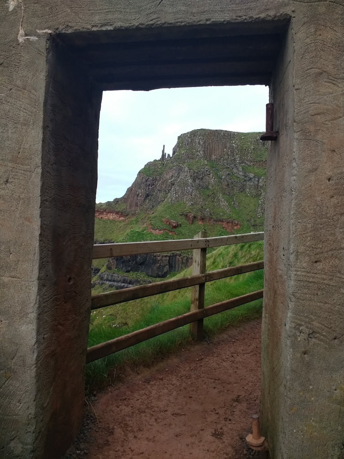
Probably the best-known site in Northern Ireland is Giants' Causeway, a five-mile stretch of coastline famous for its very unusual basalt columns. Geologists believe the causeway was formed by volcanic eruptions more than 60 million years ago. As the surface of the lava flow cooled, it contracted and formed into immense columns. One careless move too close to the edge and I would have taken an early retirement!

Rather than taking the coastal path, we chose a longer hike that took us well above the ocean so we would have a greater variety of views.

This piece of jagged headland was known as Weir's Snout.


A view along the cliffs from atop the path: We were sure glad we'd decided to walk along the path and then down the many, many steps rather than doing it in reverse, as others had, by walking up all those steps.


Steven descending the Shepherd's Steps:


This was the windiest part of the trail so we needed to be extra careful.

Some people said this rock formation was Lion's Face but I had trouble picking that out.


The rocks looked like a layered cake with two layers of rock: basalt on the bottom and lava laterite on top. This area had once been fertile soil where trees grew before it was broken down. The columns, known as the Organ, were one hundred meters tall.

I felt so tiny against the gargantuan columns.


The trail dead-ended here so we retraced our steps and followed a path down to the upright formations we'd seen from above.

Giant's Chair once had a different shape before the force of the waves and erosion changed it over time. Winds, seas, frost and rain constantly change the views.

It was impossible not to be astounded at all the varied rock formations at Giant's Causeway. This was known as Giants' Gate.

The rocks looked like they had each been placed on top of each other by human hands as they fit into and beside each other perfectly - the wonder of nature!


One of the most fantastical sights I'd ever come across was known simply as the Stones - hexagonal pillars that stood up at varying heights. People looked like they were having a blast on the uneven rock terraces but I didn't feel comfortable taking my chances trying to climb on the wave-splashed rocks.


These were known as the Onion Skins as they really do lose their outer skin from weathering over time!

This was supposed to have been a Camel with his head resting on his legs!


A final shot of the headlands again. If you ever get a chance to go to Ireland, I urge you to make sure to stop at Giant's Causeway and make sure to take the hike along the cliffs as we did before descending to the most fascinating rock formations below you're ever likely to see.

Next post: Traversing a rope bridge and then several exciting Game of Thrones sights!
Posted on October 25th, 2019, from a balmy fall day in suburban Denver before another dose of early winter is due to arrive tomorrow.
WoW ... mother nature is so amazing .. the brilliant blue skies set against the dramatic cliffs edged with their chalk white rocks bordering the roaring sea waters. And the Stones call you to play within them... loved this post and the great photos of you and Steven!! Thanks for the share....Lina xo
ReplyDelete