We'd hoped to be on a boat this morning taking us over to one of the Blasket Islands for a good chunk of the day where we'd planned to explore, take a long hike and have a picnic. But we obviously weren't in good graces with the weather gods as our second boat trip in a few days was again cancelled because of inclement weather! The other had been the much hoped for landing trip on Skellig Michael way out in the Atlantic. We improvised and decided to leisurely spend the day instead discovering more of the scenic Dingle Peninsula.
Yesterday, we'd driven halfway around to Slea Head before having to turn back for a Dingle harbor cruise, so we retraced our steps and began from the Dunbeg Fort. The admission began with a film at the visitors center next to Stone House Restaurant, a modern stone building built in just 2000 to blend in with the landscape and the region's ancient rock-slab architecture.


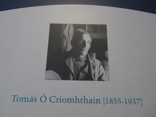
Tomas O Criomhthain, 1855-1937, was regarded as perhaps the greatest of the island writers. A farmer and fisherman, he lived all his life on the island and only learned to write in his native Gaelic in middle age as his school years were taught in English. Imagine the challenges he faced recording the life and history of his people in a second language.
Sean O Criomhthain, 1978-1978, was clearly influenced by his father's celebrated autobiography, The Islandman. His own book dealt with life on the island in the 1930s and 1940s, and was also about a young Island couple adapted to living on the mainland after leaving Great Blasket Island in 1942.


Yesterday, we'd driven halfway around to Slea Head before having to turn back for a Dingle harbor cruise, so we retraced our steps and began from the Dunbeg Fort. The admission began with a film at the visitors center next to Stone House Restaurant, a modern stone building built in just 2000 to blend in with the landscape and the region's ancient rock-slab architecture.


Dunbeg Fort sat at just 30 meters above the Dingle Bay and had been carbon dated to 580 BC although most of it was from the 9th and 10th centuries. What existed today was just half the size of what it had been. Ireland hadn't been an united country but rather it consisted of powerful families or clans constantly at war with each other to increase their holdings.


Dunbeg, built on a sheer cliff, was excavated in the 1970s. A third of the fort fell into the sea during a violent storm in 2014. Sadly, with ever increasing coastal erosion, I couldn't help but wonder how much longer Dunbeg might remain intact.

It was fortified on the landward side and had four banks and earthenware ditches or fosses. The walls were six meters thick and half as high.

The defensive earthen mounds would most likely have had wooden palisades on top.


The beehive huts were circular and dry stacked, i.e. made very carefully with layer upon layer of stone without the use of mortar and with just one doorway. Some of the huts were conjoined with two or three huts together. The entrance beehive hut would have had two guard posts.

Graduated stepped seating may have allowed for attendance at ritual and communal events and also provided an easy means of escape.

A water drain went a great distance from the fort to the road.

The bones of sheep, pig, deer, birds and fish were found but excavation results didn't reveal what the site was used for. It may have been defensive, used for ritual, status purposes or simply just have been lived in. What remained at Dunbeg was impressive for its recognition of the important tribe living in the fort. At one stage there were over 400 of these monuments surviving!

Beyond Slea Head, we faced a 20 minute delay on the narrow cliff road because a truck and campervan - local parlance for trailer - couldn't pass! There were a lot of trailers on the roads in Ireland which made for some challenging driving at times when we also came across them!


A little further on we had grand views of the Great Blasket Island we'd hoped to travel over to and spend time on. Since that was no longer an option, we thought we might as well get as close as possible to the small Dunquin Harbor where the boat was to have left from.

For centuries a small community lived on Great Blasket, their cottages looking over to Dhun Chaoin (the Gaelic name for Dunquin) whose pier was their lifeline when not cut off by storms. The island could be cut off by storms for months on end.
A sign said people stepping off the pier at Dhun Chaoin included farmers unloading livestock to sell at the Dingle market; postman Peats O Cathain who was also the island's king or community leader; the teacher Miss Fitzgerald; and tax collectors being chased back to their boats by islanders throwing rocks! When young Seanin O'Cearna died in 1947 without a doctor or priest, the islanders telegraphed President De Valera of their desperate plight. He sent supplies and later made a personal visit.

The photo showed island children lining up for their teacher to fill their mugs with cocoa in the early 1930s.

Access to the island was provided by privately owned and operated ferry companies and would have involved transferring at sea to and from an inflatable dinghy and then a hazardous landing slip!

A lovely day for a walk down to the harbor, don't you think!


It would be a slow walk back up!


A sign down at the tiny pier indicated the method that had been taken since 1984 by Irish inland fishermen to protect diminishing lobster stocks. A V-notch had to be cut in the tail of female lobsters before returning them alive to the sea so they could continue to breed and produce young, thereby safeguarding the valuable industry.

The readily identified V-notch indicated that it was illegal to land, possess or sell any lobster which had any mark or damage to its tail that might hide a V-notch, and that it must be returned to the sea if caught. To further protect the fishery, it was also illegal to land, possess or sell any lobsters smaller than 87 mm in length.

We were lucky it wasn't raining and only blustery. My raincoat helped protect me against the strong winds.


Yes, it was a bummer we hadn't been able to even take the boat over and land on the island, but, on the bright side, we had the place to ourselves to marvel in the fabulous views.


Think about coming face to face with this many sheep on the narrow path from Dunquin Harbor!

We briefly paid our respects at the cemetery where Blasket Islanders came across the sea to bury their dead as they had no church or cemetery on their island.


Since we hadn't been able to visit the island, we hoped the next best thing would be to stop at the Great Blasket Centre, a state of the art heritage center designed to give visitors an understanding of the language, literature, and the way of life of the Blasket Islanders. The center or 'spine' of the award-winning building was like strolling down a village lane with a stunning view of the actual island at the end.


Heather was an important source of duel for the islanders. Man, women and children spent many hours gathering it on the hillside during the spring and summer.

The island king, as photographed in 1903, took the lead in deciding when the sowing of crops and other seasonal activities should take place on the island.


They used wooden boats to cross over to Dunquin to attend church or to go to the hospital. Everyone knew everyone on the one mile wide by three quarters of a mile long island. The biggest treat of the week was when the mail would arrive and the islanders would hear about their relatives who had emigrated to the US. Eventually, so many young people left the island, it was evacuated in 1953.

From human remains that have been found scattered on the Blasket Islands, archaeologists know people lived on the islands about two thousand years ago. Monks then moved there to become closer to God. The islanders living on Great Blasket Island, the largest of the chain, weren't nearly as affected by the Great Potato Famine of the mid 19th century because they were far more reliant on fish than potatoes.

At the beginning of the 20th century, nearly 200 people were living on the island. They made their living from fishing and, because there was limited arable land, they enriched the soil with seaweed which produced abundant crops of potatoes and oats. Donkeys provided all transportation especially the bringing of the turf from the bogs. Cows and sheep were kept and the wool was spun and knitted into clothes by the women.


The islanders all lived together in a village called An Baile on the east side of the island. In summer, we read it could be close to paradise but in winter, it was another world altogether with the wind howling and dangerous reefs making it often impossible to cross over to the mainland for long stretches of time.


The island was their whole world and every feature had a name: An Ghort Fhada - the long field, An Leaca Dubhach - the sorrowful slope named after a fishing tragedy that left 18 women widowed. Because of its isolated location, the Blasket Islanders retained their own culture and tradition, the heart of which was their continuing use of the native Irish language.


The fame of the Great Blasket Island is due to a unique literary achievement from when a succession of scholars beginning in the first decade of the 20th century visited the island to learn Irish from a remote source that had been relatively untouched by English and the influences of a rapidly modernizing world. The scholars encouraged the Islanders, whose memories were full of stories and legends handed down through the generations, to write or record their life stories. Without the encouragement of these Norwegian, French and Irish scholars, none of the tales would have been told.
"The affection and mutual respect that grew up between these genteel scholars and sea-hardened Islanders is a remarkable example of the positive meeting of trained and disciplined minds with the keen intelligence of men and women with little or no formal education."
Of the three most renowned Blasket writers, Peig Sayers, 1873-1957, had perhaps the most traditional world view as, before she published her first book, she was recognized as a storyteller.

Tomas O Criomhthain, 1855-1937, was regarded as perhaps the greatest of the island writers. A farmer and fisherman, he lived all his life on the island and only learned to write in his native Gaelic in middle age as his school years were taught in English. Imagine the challenges he faced recording the life and history of his people in a second language.

Sean O Criomhthain, 1978-1978, was clearly influenced by his father's celebrated autobiography, The Islandman. His own book dealt with life on the island in the 1930s and 1940s, and was also about a young Island couple adapted to living on the mainland after leaving Great Blasket Island in 1942.

I found this description riveting: "The Blasket Islanders talked about going in to the island and out to the mainland as, for them, Great Blasket was home, a familiar place to go in to. They went out into the wide, unfamiliar, uncertain world of the mainland. As we mainland dwellers looks out at the island, what strikes us is its smallness set against the immensity of the ocean. But the islanders spent most of their lives with their backs to that ocean facing the mainland. It is a perspective that called up feelings of both closeness and separation."

The promised view of the rugged Great Blasket Island through the looking glass at the end of the spine was indeed worth waiting for! Visiting the center and learning about the extraordinary literary ability of some islanders and their wonderful accounts of their way of life made me regret all the more we hadn't had a chance to explore their home.


We continued our exploration of the northern part of the Dingle Peninsula, stopping at the incredibly scenic Clogher Head pullout. In the foreground was Butter Harbor, so named from when the Vikings used to stop here to grease up their hulls. In the background were the the Three Sisters Peaks.

Left of the Three Sisters was Sybil's Head where scenes from Star Wars: The Force Awakens were shot.

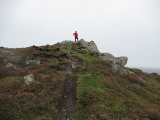
Even though it was cold, blustery and generally pretty nasty weather, we decided to still get out for an invigorating climb up to the top of the craggy cliffs. The views of the mustard-colored gorse and purplish heather were pretty magical and worth our huffing and puffing up the big hill.


The king of the mountain at Clogher Head!


Another view of Sybil's Head from atop the mountain aka the hill!


Even devoting a full day to the remainder of the comparatively tiny Dingle Peninsula, there still wasn't time to stop in more than one of the many pottery shops that dotted the road.


A few miles on, I'd sort of hoped to grab a cup of hot tea and a sweet in the tiny village of Ballyferriter that was established by a Norman family in the 12th century. But the local restaurant had the following sign on the door!


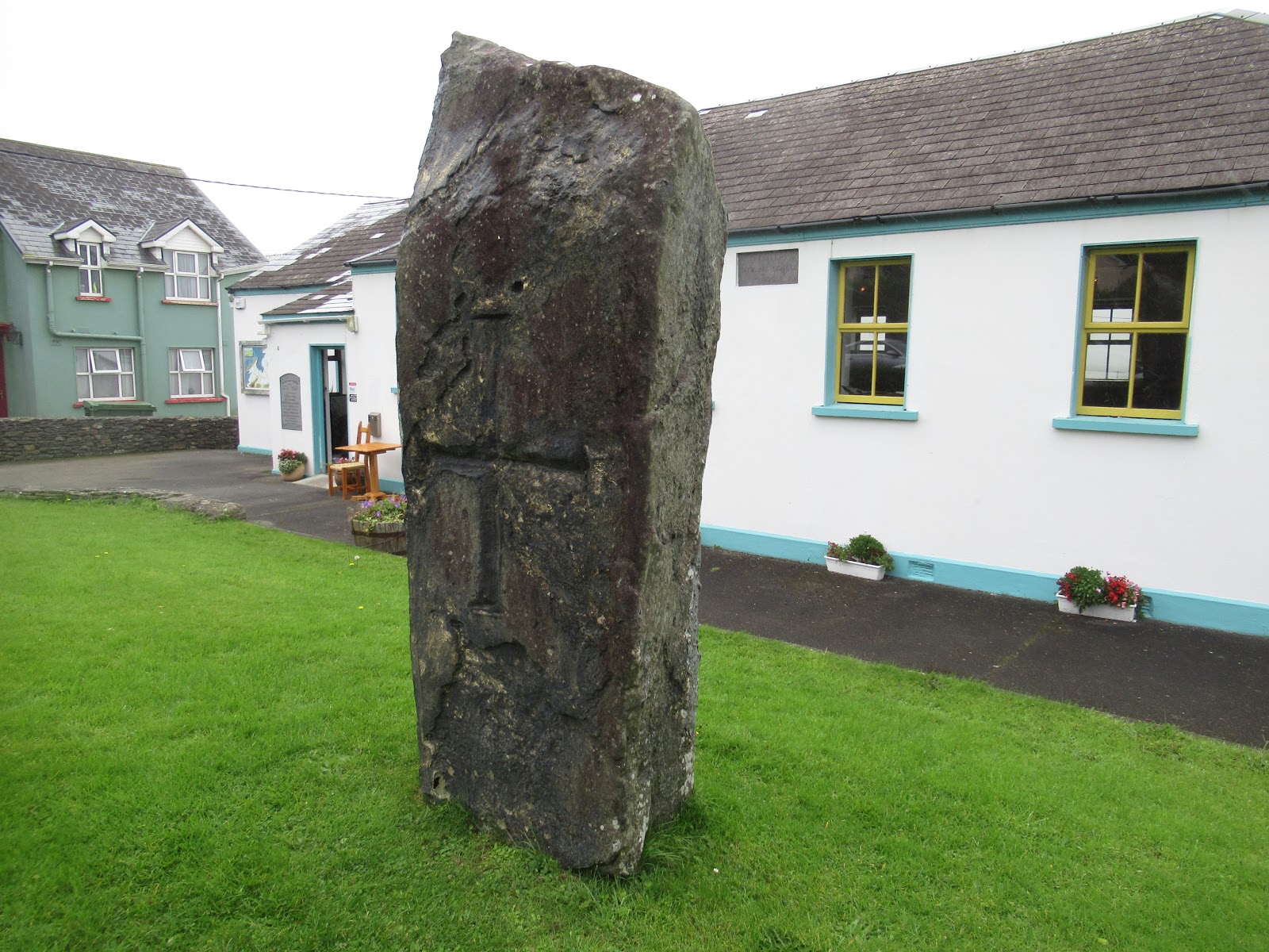
The early Christian slab in front of the schoolhouse looked real enough but, when I tapped it, I discovered it was fiberglass and had been a prop from the Ryan's Daughter bus stop scene!
A hop, skip and a jump away were the remains of Reasc Monastery that was likely founded in the 6th century and had been named for a nearby marsh. Little is known of the site's history. The outer wall was roughly circular and the interior wall was divided by a curving wall into two parts.


An oratory or small church had been constructed with dry-stone walls just like Dunbeg Fort we'd seen that morning.


In 1975, only this stone pillar was visible as the entire monastery was buried! It made me wonder what still may lie buried for future explorers to unearth.


Beside and under the oratory was an earlier cemetery containing 42 graves arranged in two rows. The area around the oratory was used as a children's burial ground after the monastery was abandoned. Beehive-shaped buildings called clochans had been the homes of the monks and were part of the outer wall.

Just a few miles further on was the Gallarus Oratory, one of Ireland's best preserved early Christian churches that we reached after walking through a path of still blooming fuchsia bushes!

Built around the 7th or 8th centuries, the oratory or chapel resembled an inverted boat! As the outward slant of the stonework directed the rain out, it was still waterproof all these centuries later! There were two openings, the western doorway and the eastern window.


As I walked inside, I marveled at how thick the walls were and the small amount of daylight allowed in via the window over where the altar would have been. The interior was so small I couldn't imagine more than a dozen monks inside for services during the medieval period.

Peek-a-boo!


One of the last sights on our tour of the Dingle Peninsula was Kilmalkedar Church, traditionally associated with St. Brendan but probably founded in the early years of the 7th century.


The present church was built in the middle of the 12th century in the Irish Romanesque style which was introduced from England and the rest of the continent when the Irish church was trying to bring itself into line with the rest of Europe. The church builder used Romanesque forms such as chevrons or zigzags and diamond shapes.


You think of Waterford and you think automatically of crystal, right? Well, Dingle had its own family-run crystal company run by Sean Daly who had been a cutter with Waterford for 15 years before it moved most of its production overseas. Sean then moved to County Kerry in 1999 and set up Dingle Crystal where all their crystal was designed, cut and polished by hand, using traditional techniques.

Sean kindly took a few moments to chat with us as he and his sons continued to work. Two pallets of glasses and other pieces are shipped out each week, he told us. They must produce thirty glasses a day to keep up with demand, all the while contending with tourists like us and bigger groups popping in for free tours! In addition to their six unique Celtic designs, Sean said he does a lot of custom orders.


After visiting the small factory, I told Steven I wanted to head back into town and look at the shop. He kindly left me alone to choose something I will long treasure of our great time in Ireland!

Next post: Winding our way further north via Tralee, the Cliffs of Moher and The Burren, surely one of the most desolate places on earth.
Posted on October 5th, 2019, from London, our last stop on this great adventure.
Loved the history you shared, loved the photos of the painted sheep marching up the narrow path from Dunquin Harbor, loved your red rain coat atop the "hill", loved Steven's smile and loved the story of Dingle Crystal ! Thanks for the tales...
ReplyDeleteI got a chill reading about your day. Can't wait to see what you got at Dingle Crystal. Janina
ReplyDelete