When planning our international trips, Steven always takes care of our flights and ground transportation, while I assume responsibility for our accommodation and sights. We obviously work closely together to make sure we're in sync and on the same page. When looking for a place in Glasgow, I somehow booked us at this B&B which was a fair hike from the city with no restaurants nearby. I can't remember the reasons why I chose this place, but I like to think it was likely a combination of price, size of our room, the fact breakfast was provided, and other amenities as convenience or proximity to Glasgow sure wasn't a factor!
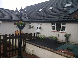


I was thrilled that only Steven and I had this large parlor all to ourselves as I was able to spend hours on the computer after Steven had gone to bed writing a blog post without disturbing him at all.

Our host, a widow whose daughter lived nearby, couldn't have been more gracious and made us feel so welcome from the moment we'd arrived a day and a half earlier. She made us delicious and hearty Scottish breakfasts both days, so much so we didn't need to stop for lunch! She also agreed to do a load of laundry which endeared her to me all the more as having access to a washer and dryer on the road is akin to heaven!

With clean clothes and full stomachs, we embarked on our drive north toward Oban in the Scottish Highlands along the west bank of Loch Lomond.

What dreamy vistas along the lake.

Halfway up the loch, we reached the town of Tarbet, the Viking word for isthmus, and a common name on Scottish maps. It was hard to think of the Vikings a thousand years ago dragging their ships across this narrow stretch of land to reach Loch Lomond.


We passed the village of Arrochar and then drove along the banks of Loch Long.

As we moved away from the lake, the road twisted up over the mountains and through a pine forest and crossing the Highland Boundary Fault. We read in Rick Steves' travel guide that the roads connecting the Lowlands with the Highlands in the 18th century were "originally a military project designed to facilitate government quelling of the Highland clans."

I am pretty sure you will agree that the rugged Glen Croe Valley was gorgeous!

The mini peak was The Cobbler aka Ben Arthur.

Who wouldn't want to stop a few minutes later at the colorfully named Rest-and-be-Thankful Pass whose name came from the 19th century when just reaching it was exhausting? The pass with its dramatic green hills was located between Glen Croe and Glen Kinglas.


At the top of the military road, there was a stone dated 1814 put there by the military with that phrase.

It was a little dreary so we had no chance of spotting a 'soot' or little bits of hillside highlighted by sunbeams as we drove further north into the Highlands. Again, thanks to Rick Steves, a 'soot' meant Sun's Out Over There!

Another idyllic spot to stop was just minutes later at Loch Fyne, a saltwater 'sea loch' that was famous for its shellfish. A popular restaurant chain throughout the United Kingdom was in fact called Loch Fyne.


Hee are more views of what I thought was the very photogenic Loch Fyne as we drove around the entire lake.


In the distance was the small town of Inverary where we'd planned to stop awhile. To reach it, though, we had to patiently wait for oncoming traffic on the oh-so-cute one-lane stone bridge.


Just past the bridge was Inverary Castle, the home of the Duke of Argyll and a stronghold of one of the more notorious branches of the Campbell clan. As the aristocratic clan still lived there, only part of the castle was open to the public. We chose to admire it from a distance as we still had a long way to go before reaching Oban that night.

These hairy cows on the grounds of the castle were shaggy Highlands cattle! They have impressive horns - unfortunately not visible in my photos - but are best known for their adorable hair that falls into their eyes and which protects them from Scotland's midges and unpredictable weather. What great yarn they must produce, right, Suellen and Janina?!


After parking the car, we walked back along the lakeshore to gaze again at the bridge and get a better look at the turreted castle.


The town's lakeside World War One memorial had a picturesque location on Loch Fyne.


The town seemed perfectly made-to-order for tourists as it was lined with cutesy shops and cafes all the way to the church at the top of its main street. As this was the geological and demographic border between the Highlands and the Lowlands, church services were held in both Scots and Gaelic.


It was a little too early in the day to be tippling the local whiskey but the historic bottles on the ceiling looked appealing!


The main site in town was the 19th century 'living' Inverary Jail where we could apparently have visited a courtroom where mannequins argued the fate of the accused and learned how Scotland reformed its prison system in 1839. But I think our time had been much better spent walking back along the shore to the castle and then to the lakefront.

After leaving the delightful Inverary, rather than heading directly north to Oban, we detoured via Kilmartin Glen which meant traveling south first and then northwest. We stopped first, though, to look at the fishing nets still along Loch Fyne.

Some of Scotland's most accessible and most important pre-historic sites were located in the wide Kilmartin Glen or valley. Neolithic people left behind fragments of their giant, stony monuments 4,000-5,000 years ago in the glen. Its most important site was Dunadd which neither of us had ever heard of before. We learned it was one of the most important sites in Scottish and Irish history. Sitting in the raised bog of Moine Mhor, it was chosen as the royal capital of the earliest Scottish kingdom, home of the Dalriada, also written as Dal Riata.

According to medieval texts, kings from Ireland came here in the early 6th century and ruled their kingdom from Dunadd. Their descendants became the first kings of Scotland, and their people, called Scotti, became the first Scots and they eventually gave their name to Scotland. The language of the Gaels came to dominate much of Scotland. Although Scotti was applied by Latin writers to people who spoke Gaelic, it also meant pirates! Though still spoken today, the use of Gaelic has declined significantly.

Though this area is often regarded as remote, over 1,500 years ago it was the cradle of Scotland, the springboard of an emerging country. Royalty who lived here were well-connected in contact with important groups and individuals. Sea, sailors, and ships all played a key role. Gold, dyes, herbs, and wine were obtained from different corners of the world. Within their defended walls, kings and friends drank expensive wines and ate exotic foods. Some luxuries were often given to neighbors to cement friendships. Historical texts reveal that St. Columba, an early Christian monk, crowned King Aidan as the first Christian king of Scotland. The Word of God then spread across the region.

The royal center had strong links to the spiritual center of Iona, 60 km to the west. St. Colomba, the monastery founder, was granted his island here by King Comgall in 563. Dunadd was once an international hub where diplomats, traders, and royal refugees came from across Western Europe. The discovery of precious metals and rare minerals, fine pottery, and glassware revealed how well connected Dunadd was between the 6th and 9th centuries.

A carved stone ball found at Dunadd was one of many made across Scotland, particularly in the northeast, up to 4,000 years ago. According to local legend, stone balls and other artifacts with magical powers were abandoned by fairies in a farmhouse below the hill fort.

We climbed the steep, rocky path to the heart of the fortress to discover ruined ramparts, traces of buildings, and see for ourselves the inauguration stone where kings were made.

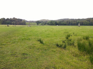
There were magnificent views of Kilmartin Glen once we climbed to the top of Dunadd and across Argyll.


Dunadd fell to the powerful Pictish warlord Aegnus in 736. Some scholars believe it may never have regained its independence and that the fortress became a ceremonial center used to maintain control over Dal Riata. I also read that by the 9th century, the Dalriadan kings had extended their control over much of Scotland and established their place in the political life of northwest Europe. I am unclear whether Dunadd fell in the 8th century as I read in one text or whether it was still powerful a century later as described in another!

According to a map at the top, these 'lumps' were traces of buildings. Workmen armed with picks and shovels sifted for artifacts here during excavations in 1904-5. Modern archaeology revealed more about Dunadd from four small trenches in 1980-1, including its Iron Age roots and its 7th century metalworking.

Steven was over by the site's well.


Ireland is rightly called the Emerald Isle but this spot of Scotland looked especially verdant. As you might already guess, the little white dots in the two photos were sheep!


At the stone atop the hill, we saw the size six footprint where kings placed their shod foot. When kings of Dal Riata placed one foot in the footprint to be inaugurated, they were betrothing themselves to the land that fed their people. In Ireland, where six such royal footprints are known, records claim that the stone recognized and proclaimed the rightful king.

As Dunadd was so firmly rooted in the ancient, ancestral landscape of Kilmartin Glen, it was still considered important enough for the reading of royal proclamations in the 1500s.

We could faintly see inscribed on the stone a boar which was a Pictish emblem as it possibly symbolized sovereignty.

We could also just see Ogham, a Gaelic script used until the 11th century. According to one theory, Dunadd's Ogham script was the voice of the rock during the inaugurations. While its meaning is disputed, current research suggested some parts translate as "People of ..." and "Men of the Moss," a reference to the Moine Mhor.


A leap of imagination: In legend, the hero Ossian lept here from Rhudle Hill, 1 km away. His foot gouged out the footprint, his knee the basin, while his outstretched hands left fingernails, possibly the Ogham script.


This painting of Dunadd was done in 1833 before its significance began to be appreciated.

The remarkable heritage of Dunadd was increasingly recognized in the 1800s. The hill fort was now protected by Historic Scotland. Thank goodness we had taken the time to detour to this part of the remarkable Kilmartin Glen for its intriguing history and spectacular views rather than making a beeline for Oban


Just a few miles further north was a turnoff for Dunchraigaig, a remarkable collection of ancient monuments built and used between 4,000 and 5,000 years ago. Its extraordinary collection was part of Scotland's most important archaeological landscape known as Kilmartin Glen. We looked forward to discovering ancient burial cairns, walking among standing stones, and looking out for art carved into rocks. The only henge or neolithic monument in western Scotland was probably used for religious ceremonies.

All these were the remains of a landscape that once was full of power and meaning. A sacred place where early people celebrated named and remembered their ancestors. We crossed the road to step into their past.

An unusually large number of people - between 8 and 10 - were buried in Dunchraigaig Cairn, a cist with a massive capstone. This may have been an earlier, possibly Neolithic grave, but the bones were no longer there so radiocarbon dating could not be performed. In 1870, Rev. Reginald Mapleton described the bones then as "the consistence of butter, or new cheese, and seemed to almost to melt between the thumb and finger."
When Dunchraigaig was excavated by Mapleton and a religious colleague, they found two decorated pots, flint chips, and human remains inside the graves. Among the cairn stones were a whetstone to sharpen metal, a stone ax head, a flint knife, and pottery but all that has since disappeared.
When Dunchraigaig was excavated by Mapleton and a religious colleague, they found two decorated pots, flint chips, and human remains inside the graves. Among the cairn stones were a whetstone to sharpen metal, a stone ax head, a flint knife, and pottery but all that has since disappeared.

Cremated bones were placed inside another grave that was no longer visible. A third cist, inserted after the cairn was built, housed an unburnt body and cremated bones. It was interesting to read that a woman in the 1800s forced her husband to return a bronze dagger supposedly found in a nearby cist. She feared that the dead man's ghost would haunt them!

We then traipsed across another field to Kilmartin Burn. When people started farming here around 5,000 years ago, they didn't spend all their time plowing fields and tending cattle. They erected stone settings and circles and carved into the rocks. They created a powerful landscape that was important to their spiritual and political beliefs.


The standing stones came in different shapes and sizes; some were single stones, some arranged in rows or crosses, others as circles. Thay may have been important places to meet or possibly an early form of a calendar.

Early people carved strange shapes, like cups and rings into boulders, standing stones, and cairns. Although historians don't know what they meant, they were clearly important as there were hundreds of examples across the landscape.


We read that Alexander Thom, an advocate of archaeoastronomy - a field of study I'd never heard of before - claimed this was one of the most important lunar observatories in Britain. Recent analysis supported the idea that the stones marked where the moon rose and set at key points in its 18.6-year cycle. It was amazing to learn that the standing stones lined up with the midwinter sunrise and the fall and spring equinox sunset.

Individuals and symbols of power: As time passed people continued to use Kilmartin Glen to make powerful statements to build on their past. Earlier monuments were still recognized as special places. Individuals were buried in their own graves within stone circles, henges, and chambered cairns, sometimes with magnificently decorated pots and jewelry. Some of the graves had motifs carved into them, such as bronze axes. Although used in everyday life, these objects had wider significance, symbols of power, and prestige within the community.

Across the field were the mysterious Temple Wood stone circles. Over 5,000 years ago, a wooden circle was built but it was later replaced by stone circles. There were 25 sites with standing stones in this area.


The arch over the nearby Kilmartin Church of Scotland gate honored those who served in World War One. The inscription read "They died that we might live." It wasn't known when the first medieval church was built here in the heart of an important pre-Christian landscape.


The three medieval stone crosses that stood inside the church were reminders that this had been a site of Christian worship for at least 1,100 years. The crosses had been brought inside the church to protect them from the elements.

The intricately-carved Kilmartin Cross was created in about 900 and stood by a magnificent medieval ringed cross that could date to the 1100s. Under the direction of local clerics, craftsmen carved intricate designs on one side. At some point, one arm snapped off. The other side was later decorated to fit the broken shape.

The cross was one of the most magnificent stone crosses in the West Highlands. On one side was the robed Christ, sitting with arms raised to show his wounds. On the other side was the crucified Christ with a winged lion, a symbol of St. Mark, an angel for St. Matthew above, and a winged bull for St. Luke below. The cross originally stood 400 meters away but was later moved to the graveyard. In 1973, the top arm was recovered from a drain and fixed back in place when the cross was brought inside.

The smaller cross had stood in the graveyard from about 1400. Its style matched that of yet another cross, the Kilmichael Cross, displayed in the adjacent museum.

We wandered out to the cemetery behind the church to view the Kilmartin Grave Slabs, 23 intricately-carved stone slabs collected from the churchyard.

I first looked at this MacDonald gravestone as that was my maiden name! When Steven and I married, I gave my maiden name up as I didn't want to be known as a MacDonald Berger!

In keeping with European fashions for commemorating the dead, the slabs had a distinctive artistic style that was part of a great flowering of Gaelic culture in the Middle Ages. Most were probably carved where the stone was quarried, about 7kms away, and then transported to Kilmartin.


More than half of all medieval West Highland sculptures depicted swords as they were symbols of military prowess. Another common scene was of dogs attacking a stag as hunting was a prestigious pursuit reserved for the elite.


Symbols of royalty such as lions and unicorns were also included.


As the elites were so concerned about their appearance, shears were included on several slabs!

A burial aisle was built for Neil Campbell and his wife in 1627. Part of a pioneering Protestant dynasty, Campbell was Bishop of Argyll; his wife was the daughter of the Bishop of the Isles. Two of their sons grew up to become bishops.

In the attached Poltalloch Enclosure were seven more grave slabs of medieval warriors and two tombstones from the 1600s. All but one were reused and inscribed with the name 'Poltalloch.' This was probably done after the Malcolms of Poltalloch bought the Campbell of Kilmartin estate in 1827. The Malcolms preserved many of the glen's prehistoric monuments.

We noticed the same themes on these slabs, too.


This was a reconstructed Monks Cell or Beehive Hut and reminded us of those we'd seen a few weeks earlier when we'd spent a month driving around the Republic of Ireland. The Kilmartin village name meant 'the church of St. Martin.' The Gaelic word for church, cill, came from the Latin word cells, which was often used for small church settlements and church buildings, sometimes like this beehive hut. This is where the English word cell came from.
Early churches were made of stone. Known in Gaelic as a clochan, this kind of hut was used in both religious and secular sites in the early Christian period. A typical beehive hut would be two or three times the size of this reconstruction that was built in 2002 by a stonemason from France. The densely packed stones, built without mortar or any wooden supports, provided a wind and watertight shelter.

Many places in Argyll had this cill form of the name, which suggested that early medieval Christians in the area were well provided with pastoral care. As there were at least eight cill sights, all within 10 km from here, no one had to walk far to find a priest!

If you ever have a chance to drive through the Western Highlands and have at least a passing interest in history, I urge you to consider stopping at Kilmartin Glen for a few hours. You will see for yourself why it has been described as Britain's richest archaeological landscape, surrounded by 800 monuments and massive stone cairns built over 3,500 years ago!
As we headed north of Kilmartin Glen toward Oban, the landscape changed dramatically.


As you might imagine, we were quite relieved to finally arrive at our hotel in the resort town of Oban in the early evening after stopping at so many places en route from Glasgow.


As our room fronted Oban Bay, we had marvelous views of the Esplanade but we didn't dally long as we wanted to explore a bit before dinner.

Further along the esplanade were idyllic views of Asknish Bay.


Eilean Arsa or the Ancient Island and Craignish Peninsula looked very mysterious at nightfall.

In the distance was the 785 meter-high Isle of Jura and the 757 meter-high Isle of Shuna, collectively known as the Paps of Jura.


Knowing we'd be visiting another distillery in a few days, we didn't mind too much also not being able to stop at the Oban Whisky Distillery that was founded in 1794 and produces 25,000 liters a week, much of that exported to the US.

About the last place I expected to see an art nouveau-style building was in the port city of Oban!


Sunsets are always special but I think they take on an extra beauty of their own over water as they did that night in Oban.


Next post: A fabulous day trip to the Hebrides islands of Mull, Staffa, and Iona.
I am also writing blog posts about our most recent trip to Sri Lanka and India that were supposed to have been part of a four-month-long trip to Asia and the Middle East but was cut way, way short because of the coronavirus. Here's a link to the latest post about our tuk tuk tour of the devales and temples in the mountains north of Kandy:
Posted on April 26, 2020, from our home in suburban Denver. Please take care of yourself and others in these tough times.