Earlier in the day, we'd driven across the Dingle Peninsula to the market town of Tralee, on to County Clare via a small ferry and then to some of Ireland's most scenic countryside with drop dead gorgeous views of the almost empty Kilkee Cliffs. The most famous cliffs, though, were the Cliffs of Moher but we wondered if they could possibly surpass what we'd just been wowed by at Kilkee.
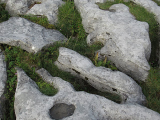
In the visitors' center, we saw a display that indicated the cliffs' flagstones were a valued product in the 19th century as they were prized for their ability to break naturally into thin sheets which could be then easily quarried by hand. The highly textured surface patterns were formed by the fossil tracks of marine animals that lived 320 million years ago. The flagstones were exported by ship from Liscannor Harbor to pave English streets and adorn famous buildings such as The Royal Mint in London and St. George's Hall in Liverpool. The invention of concrete wiped out the business but the demand for Moher flagstones has returned.
Kilfenora only became significant when it was officially recognized as a diocese - a district with its own bishop - in 1152. Because it was a diocese, the church at Kilfenora was called a cathedral.
The most important one was the Doorty Cross, the shaft of which had been formerly used as a tombstone for the Doorty family in the 18th century. The figure of a bishop with a conical style mitre dominated the head of the cross with angels or birds perched on his shoulders.
When you looked at the preceding photo, did you happen to notice the carved head above the doorway?!
Further on, the shell of Leamaneh Castle was closed to everyone except, according to Rick Steves, the female ghost that still haunts the 15th century former tower house!
At the time this tomb was constructed, the landscape would have looked quite different from what we were seeing. Open pine forests with some elm and hazel trees were widespread and there were limited areas of open grassland.
The Burren was completely different from anything I'd ever seen, something that is becoming increasingly rare with our having explored so much of the world the last seven years especially. As barren as it was, I found the area just beautiful as long as I didn't need to walk very far in it!
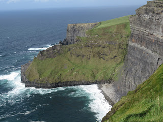
The Cliffs of Moher take their name from a ruined promontory fort 'Mothar' which was demolished during the Napoleonic wars to make room for a signal tower.
The highest point of the cliffs was O'Brien's Tower, built in 1835 as a viewing point for tourists who flocked to the Cliffs of Moher. Amazingly, views of five counties could be enjoyed on a clear day apparently from there!
If we used our imagination just a bit and squinted our eyes a whole bunch, we thought we could see the Aran Islands where we'd be in a few days in the distance!
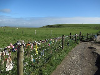
A protective wall of local Liscannor slate kept visitors safely back from the edge of the cliffs. For years, though, the Irish didn't believe in such protection and anyone could walk right up to the edge as we'd just been able to an hour or so earlier at the spectacular Kilkee Cliffs.
That philosophy changed when there were numerous fatal accidents and suicides. As a result, 'rangers' were hired to theoretically answer questions and lead tours, but were there in reality to make sure people didn't get too close to the cliffs. The wind was strong enough when we were there, particularly in certain spots, that I could just imagine how sudden gusts could be strong and deadly.
However, the fencing was only present in the most touristed area - beyond that, we just headed along the well worn path as far as we could go to the north cliffs!
For thousands of years, people at Moher have survived along the edges of this windswept and stormy environment by harvesting the cliffs, shore, sea and pastures. Poor soil and bad weather forced farmers to supplement their livelihood from cattle and sheep grazing because the fields around the cliffs had fairly acidic and poorly drained soil. They were totally exposed to the salt-laden winds and rain that regularly lash the Atlantic coast. Farmers supplemented their income by fishing or quarrying.
As most farmers today still need off-farm incomes, some have developed businesses producing artisan cheese and jams or selling their products directly to consumers at farmers markets.
The monster waves that beat against the cliffs on stormy days are coveted by extreme surfers who work side by side with rescue helpers on jet skis just in case!
Sea Stack:
What Steven and I loved so much about our brief time on the nearby Kilkee Cliffs was the almost total absence of people compared to the much ballyhooed Moher. It doesn't look like it from these photos but we saw hundreds and hundreds of people climbing up to the cliffs from the immense parking lot to access cliff views. Though many chose to stay by the protective fencing at the north platform, we could never get away from a long line of people who wished to explore the edges of the cliffs further afield. We were there in the late afternoon which may have been a busier than normal time, I don't know, but I found the commercialization of the site with its many stores selling souvenirs and snacks off-putting.
The Cliffs of Moher are a Special Protected Area under the EU Birds Directive and home to Ireland's largest mainland seabird nesting colony with 20 species of nesting birds. We could hear some of them making a fearsome racket but it was so tough actually catching sight of them so I could take photos.
Bird catching and egg gathering on the cliffs was a dangerous practice until WW II. I had read in the visitors center earlier that twelve to fourteen hardy men would sit in a row one behind the other, each holding onto a rope. The man in front would tie the rope around himself and then be lowered gradually over the cliff to a bird's nest. Upon reaching the nest, he'd use a fishing pole with a noose at the end and then place it gently over the head of one of the birds, draw the unsuspecting bird to him and then, poof, snap its neck!
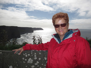
Being the far more adventurous one, I walked right out to the edge and around this almost negligible barrier, something I wouldn't have done a few years ago when I was even more afraid of heights. I remember holding onto that skimpy little post and thinking, I hope it stays put for a little bit longer. You can see it was pretty breezy by my coat blowing in the wind.
When I looked down, there was nothing but the bright blue sea far, far below!
This was the sign I chose to ignore but luckily not to my peril!
Were we glad we'd also gone to the Cliffs of Moher? Absolutely, without a doubt but I didn't 'get' the hype about them compared to the equally lovely and crowd-free Kilkee Cliffs. To have been at both sights on a day where the sun shone was as picture perfect as it could get. Once we reached the end of the cliffs, the clouds began rolling in so our timing couldn't have been better.
On the way to Galway, our destination for the next couple of nights, we stopped in the very small town of Kilfenora. We were there too late, unfortunately, to see its Burren Centre and the video about the geology and botany of the region so we spent some time at the ruined church next door. Mass was still held in the church which claimed the pope as its bishop by papal dictate. As the smallest and poorest diocese in Ireland, Kilfenora was almost unable to continue after the Great Potato Famine. As a result, Pope Pius IX in 1866 supported the town by personally declaring himself its bishop.
At least six and possibly seven medieval stone crosses survived at Kilfenora which made it one of the largest concentration of that kind of monument at any site in Ireland. Carved from local limestone, the surviving crosses and cross fragments were quite similar in style and believed to have been made in the 11th or 12th century, a period that coincided with the recognition of the church administration in the country. Some of the crosses had served as boundary markers as they had been located close to the four roads that run into town.
The most important one was the Doorty Cross, the shaft of which had been formerly used as a tombstone for the Doorty family in the 18th century. The figure of a bishop with a conical style mitre dominated the head of the cross with angels or birds perched on his shoulders.
The North Cross survived relatively intact. Unlike other High Crosses here or elsewhere we'd seen in Ireland, this one didn't have a ringed head.
Further on, the shell of Leamaneh Castle was closed to everyone except, according to Rick Steves, the female ghost that still haunts the 15th century former tower house!
Since leaving Kilfenora, we'd been in an area called the Burren, literally the 'rocky place.' The ten-square mile limestone plateau was so barren that a surveyor in the 1650s described it as "a savage land, yielding neither water enough to drown a man, nor a tree to hang him, nor soil enough to bury him!" But that hadn't been evident as we headed north toward Galway Bay until we reached Poulnabrone Dolmen. The change in the landscape was among the most dramatic and startling of anything we've seen.
We had to get our heads around how drastically the landscape has changed over time by man since they first arrived over 6,000 years ago. By clearing the land of trees for pasture, it contributed to the characteristic bare look of the Burren.
Large stone tombs, known as megalithic tombs, were built throughout Western Europe during the Neolithic or New Stone Age when farming was becoming more established. Over 90 megalithic tombs have been found in the Burren; Poulnabrone, one of the earliest portal tombs, was built in the 4th century and was the best preserved.
I'm not nearly as sure-footed as I once was so I found it pretty treacherous making my way over to the tomb, thinking I was about to break one of my feet again on the uneven terrain.
While it looked like a stone table, it was actually a portal tomb situated in a karst limestone plateau 150 meters above sea level. The tomb was constructed from great slabs of limestone over 5,000 years ago. In contrast with the impermanent homes people built for themselves, they built substantial stone tombs for their dead. Two hundred years ago, locals called this a druids' altar. Five thousand years ago, the cairn of stacked stones was a grave chamber. Archaeologists have discovered the remains of over 30 people at this ancient site.
The investment of labor represented by the tombs and their continued usage over a long period of time suggested to historians they served a powerful role in their communities. The tomb was an enduring reminder of a sacred place.
Except for the clumps of grass and a few wildflowers, the place seemed devoid of life. I saw and heard no birds and no animals. I read, though, the starkness of the Burren has begun to be reversed in parts by changing farming practices that have led to the growth of hazel trees.
Not ten minutes later, the rocky landscape was merely a very pleasant memory and a scene of utter pastoral beauty was upon us for most of our remaining drive into Galway.
Next post: Galway town and a terrific music show called Trad on the Prom!
Posted on October 8th, 2019, from London, on our last night of what's been a fabulous six week trip to the Republic of Ireland and the United Kingdom. I will continue writing the remaining posts as often as I can as we prepare for our next trip, a month from now, to Antarctica, Patagonia and Paraguay.


So impressed that you could stand so close to the edge of the Cliffs of Moher , Anne !! You have far more nerve than I !! xo
ReplyDelete