Most tourists while in County Cork spend their time in the city of Cork, the biggest in southern Ireland, and at the Blarney Castle and Killarney. After reading Rick Steves description of the "spit-slathered Blarney Stone," we gave both the city and the stone a wide berth! We preferred to spend our time in nearby Kinsale, a more historic and cuter coastal town but had arrived too late the previous evening to see any of the town's sights after touring Jameson's Distillery and charming Cobh en route.
Along the harbor front was the replica of a Spanish Galleon Mainmast as dozens of ships from the Spanish Armada moored in tiny Kinsale to threaten England as both Ireland and Spain had a common religion and enemy, Catholicism and England.

We had reservations for a boat cruise in the harbor later so hoped the drizzle would let up.


The sign looked just like the little cafe; funnily enough we had a light supper there much later before heading back to our B&B as it was a ways out of town. The flower-filled 19th century 'tumbler cart' used to be rolled through town like a garbage truck collecting human waste from Kinsale's citizens before spreading it as fertilizer on the fields outside of town

By the cart was a model of medieval Kinsale in 1381 when England's King Richard II declared that Kinsale should be bordered by a stone wall as it was situated by the sea and had been recently attacked by Spanish and Irish enemies and English rebels. The wall survived for several centuries and provided safety for its inhabitants as a safer trading destination.

The cheery or almost borderline psychedelic-colored shops:


In the center of the old town was the Dutch-styled former Courthouse and now the Kinsale Regional Museum. Its architecture reflected the influence of the Dutch-born King William of Orange at the end of the 17th century.

The museum had lots of information about the controversial Lusitania tragedy because the luxury ship was torpedoed in 1915 just 12 miles off the coast which meant that Kinsale had maritime jurisdiction over the waters.
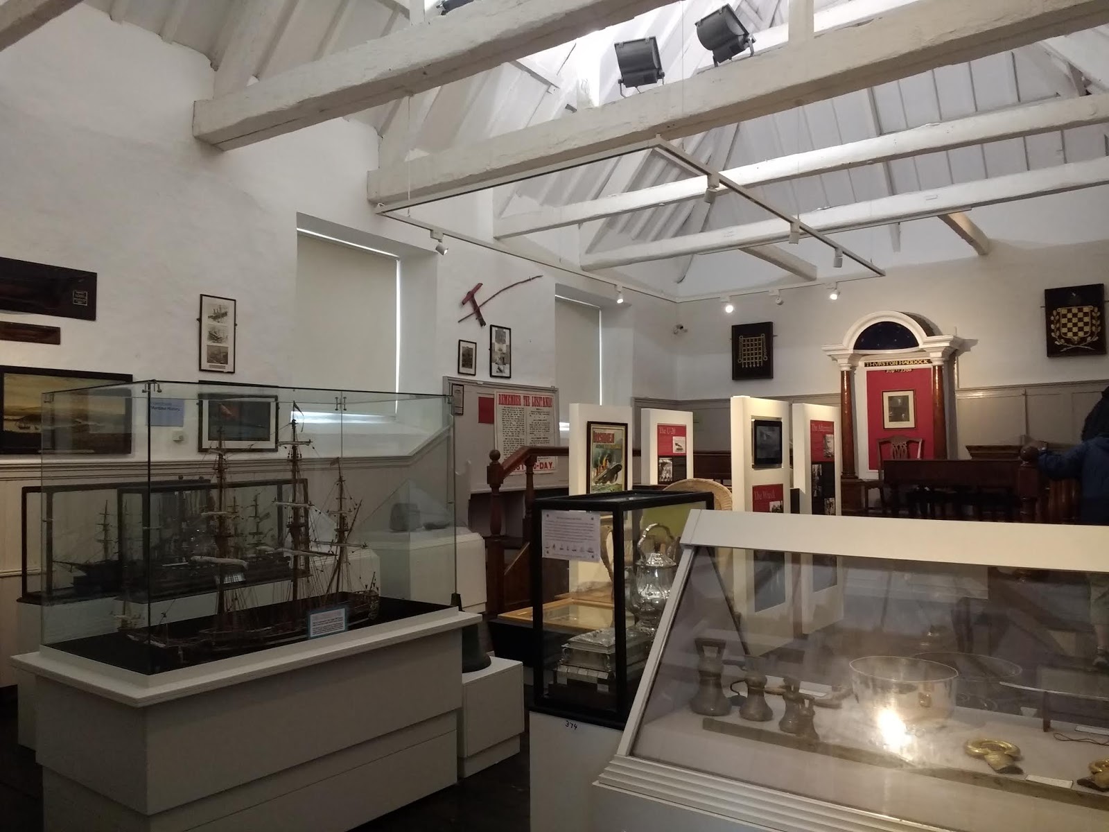
Hearings were held in this courthouse shortly after the sinking to seek the causes and, according to Steves, describe the Germans as bloodthirsty villains. The Germans' claim that the liner was illegally carrying firearms and using the passengers as human shields was provoked by the huge explosion and ship's unusually quick sinking. As many Americans had been on board the Lusitania, the disaster helped propel the US into WW I.

It was quite eerie seeing the wicker deck chair from the ship. After touring the far better Lusitania exhibits in nearby Cobh the day before, I'd had enough Lusitania info for a good ling while.

An hour or so later it was still dreary along the harbor but the flower boxes throughout the town were delightful! We'd found some free parking so decided to get some much needed exercise after being cooped up in the car and headed out to the star-shaped Charles Fort on the Scilly Walk which connected the town and the fort.


The pub was called The Spaniard in honor of the town's Spanish links.


Great view of Kinsale's remarkable harbor which made it an important port since prehistoric times because the bay's ten-foot tide gave it a natural 'shuttle service' for Stone Age hunters and gatherers. From 500 BC to 500 AD, Kinsale was a large trading center. The city's importance was at its prime from the 16th to the 18th centuries when sailing ships ruled the waves and maritime countries into global powers.

Ireland's most perfect harbor at Kinsale and its location as the gateway to both France and Spain provided a base for either country to cut off English shipping. Two great forts were built to combat these potential threats from the Continent as England couldn't rule the waves without controlling Kinsale. One of those forts was Charles Fort, our destination on the other side of the bay.

We didn't realize until later this was a tender, a small boat that transported passengers to a waiting cruise ship in the bay.

The Scilly Walk, so named because the opposite side of the bay was named Scilly instead of Kinsale, took us past dry stone walls with spectacular flowers, quaint cottages and marvelous views of the bay as the sun finally appeared. Scilly, I later discovered, was a fishing village settled by people from southwest England in the late 1700s.


Bulman Bar in the community of Summercove looked appealing but we trod on toward the fort.

Across the cloud-filled bay was Kinsale!

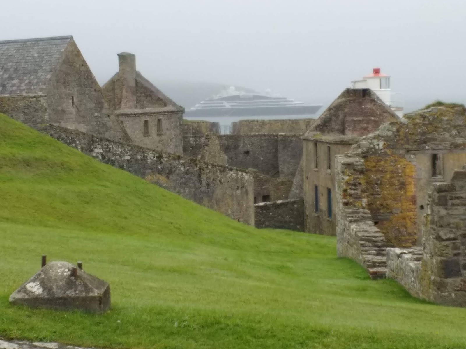
Charles Fort was set up at the mouth of the harbor and, when it was built, it was Britain's largest star-shaped fort, considered a state-of-the-art defense because its star design made defending any attack on its low thick walls safer and more effective. The fort was occupied by the British until Irish independence was achieved in 1922.


Canons positioned on the fort's extensive seaward defenses made it impossible for enemy ships to enter the harbor. Construction began in 1678. The builders received the not so princely sum of 200 pounds and had to provide all workmen including masons, laborers, quarrymen, boatmen and also all materials! Laborers worked twelve hour days and received a daily rate of sixpence, a token amount even accounting for the cost of living then and now.

In the large Barracks Stores building we learned that though 1,200 British men were training here at the beginning of WW I, normally there were only 400 on the 12-acre site. The military officers were all married and had their wives and generally five children each present with them. Their lives continued at the fort largely as if they had not been on the base as they still had their retinue of servants.

The signage at the fort was, quite frankly, abysmal so, while it was moderately interesting to walk around and explore the ruins, I didn't feel I got much out of our wander about the fort. As you have no doubt gathered by now, I love to absorb 'facts and figures' when we come across new places and Charles Fort wasn't that sort of place.
One sign indicated through a small opening on the right was a Sally Gap but without further explanation which wasn't much help for those tourists unfamiliar with forts. A 'gap' I learned later was an opening which seemed logical but hadn't before in a military sense. Perhaps it was a British colloquialism!


The declaration of war in 1914 had far reaching consequences for Kinsale, Ireland, Europe and the wider world. If you remember history, the Great War saw the mobilization of 65 million people under arms and the loss of 20 million civilian and military lives. I read that Ireland played an important part in the war with more than 200,000 Irishmen voluntarily enlisting in the British army. Many enlisted because severe economic conditions meant they would receive a steady wage plus a separation allowance if they were married.
It was estimated that 35,000 Irishmen died during the war, 176 of whom were from Kinsale. With a population of 4,020 in 1911, that was a significant number. The Royal Navy and Merchant Marine were popular enlistment choices for Kinsale men as their coastal town was under constant threat from German U-boat activity. Recruitment posters:

Kinsale across the bay from the fort:


The Barracks Building on the top left was where we began our walk of the fort.

When we bought our entrance tickets, we'd been advised to be careful because the rocks were slippy as they were wet!

No idea what these buildings had been, sorry!


These were the Infantry Barracks that were built in 1750 where ten to twelve men would have lived in each room which seemed impossible to comprehend as they were so small.


What a shame there wasn't much better information at Charles Fort available for those like me who thrive on understanding what they're seeing. My takeaway was it'd been worth it as the long walk out to the fort and back had been invigorating, and we hadn't missed out on not seeing something else in Kinsale because we'd elected to tour the fort. Plus, the company, as always, was great!

We scooted back to Kinsale the same way we'd come out as quickly as we could so we could make the earlier boat cruise of the harbor. I kid you not, this was a road and not just a path for walkers and cyclists!


We were quite relieved we managed to reach The Spirit of Kinsale in time for its earlier departure from the Kinsale marina as it'd been a long hike back all around the peninsula.


As we left the harbor, we listened to a recording stating that the only commercial fishing done in Kinsale now is shrimp and it's sold to the fish markets in Paris. I believe I heard the shrimp fishing window was just from August through October.

This turned out to be the French cruise ship the tender had been making repeated trips out to while we'd been walking to and from the fort.


Across the harbor from Charles Fort was another fort atop a hill, James Fort, built before 1607 and referred to as the 'old fort.'

On the far left was the orange colored Bulman Bar in Summercove we'd walked past en route to and from the fort.

It was neat to approach Charles Fort from the harbor as compared to by land as we'd just done. The fort was burned down in 1923 by anti-Treaty IRA forces during the Irish Civil War and was declared a national monument in 1973.


As we returned to Kinsale, there was a hint of a blue sky.


Kinsale is a haven for fishermen with plentiful mackerel, monkfish, etc.


A memorial by the harbor was dedicated to the men and women who participated in the war for Irish independence in 1916.


I thought of you, Zachary, when I spotted this Proseco sign.

Since visiting Kinsale two weeks ago, we've seen several other fun slogans for Guinness!

The Anglican St. Multhose Church looked more like a fortress with its tower! It dated back to the Middle Ages though it was obviously rebuilt in recent centuries.

The simple base of the baptismal font is thought to have dated from the 6th century.


The stained-glass windows were captivating!

As fishing was always important in Kinsale, the vivid colors in this set of stained glass windows depicted the Bible scene that has Jesus helping Peter, James and John to catch fish.

This window memorialized the 21 members of the parish of Kinsale who died in WW I. The scene depicted the Risen Christ blessing two Roman soldiers from his day.

Never had we seen a memorial window with a face almost like a photograph. It depicted Lieutenant Stephen Lewis who died while serving in Gallipoli, Turkey, in August of 1915, as a medieval knight. I wondered why he alone had been singled out to merit such a striking and very memorable window.

Two horizontal concrete graves marked the final resting spots of some of the victims who died in the Lusitania disaster.

I really enjoyed our time in Kinsale: an attractive harbor with gorgeous flowers, great shopping, interesting little museum, an invigorating walk to the fort, lots of restaurants and bars, a harbor cruise but the neon-colored homes will likely be nearer the bottom of my pluses about Kinsale!


If i hadn't seen two cars pass each other, I would have thought this couldn't be a two-way street! The streets were so narrow because they'd been built in the medieval era when the town was laid out.

This was our very charming B&B and its marvelous garden located in Kilcatten, a good piece away. Appearances were deceptive as our en suite bathroom was minute and the bedroom's lighting was abysmal! On a very positive note, though, the hostess was delightful and the Irish Breakfast was another heart attack special!


Next post: More of the Wild Atlantic Way through Galley Head, Toe Head and the heartbreaking Famine Cemetery in Skibbereen.
Posted on September 19th, 2019, from Portrush on the very photogenic Antrim coast in Northern Ireland.
I agree with you -- neon coloured "exterior" paint should not be made or sold ! xo
ReplyDelete